2.30 m VHF: Channel 69 Report an Incident

Safety & Navigation

Navigation

Approaches to Cowes

Cowes Harbour is the main commercial port for the Isle of Wight and one of the foremost destinations for sailors in the world. It can be entered day or night and at all states of tide by vessels with draft up to about 3 metres depending on the height of tide.

  • Cowes can be approached safely from the north, east, and west. When approaching from the north, care should be taken not to infringe large vessels in the Southampton Precautionary Area Southampton VTS Notices to Mariners. Vessels over 150 metres in length have a Moving Prohibited Zone that requires smaller craft to keep a minimum of 1,000 metres ahead and 100 metres either side
  • The Southampton Precautionary Area can be avoided completely by smaller vessels when taking passage from Southampton Water and the River Hamble, when height of tide permits, by passing to the east of the Bramble Bank and entering Cowes via the Eastern Channel
  • Vessels approaching from the east should look out for the Shrape Beacon, about 300 metres northwest of Old Castle Point. The Shrape Beacon marks the northern extent of the shallow Shrape Watersports Area
  • Vessels approaching from the west need to keep a close lookout for unlit mooring buoys inside the large Gurnard North Cardinal Buoy, and watch out for yachts starting and finishing races off the harbour entrance

All vessels approaching Cowes should do so at a safe speed, maintain a good lookout and give full consideration to other vessels, many of which are manned by inexperienced crews

Cowes Breakwater

The Cowes Breakwater is marked with five GPS-synchronised yellow lights spaced equidistant along the breakwater crest, displaying flash characteristic Fl.Y.2.5s.

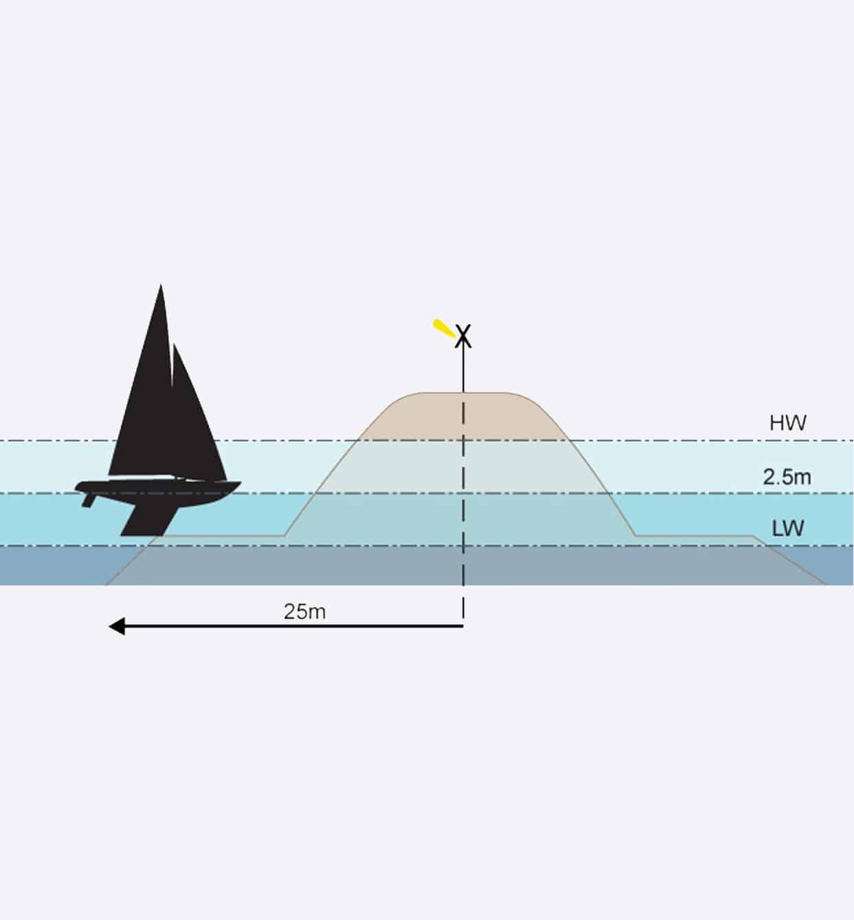
Stay at least 30m from the breakwater crest, the rock-armoured structure extends 25m to the north and south

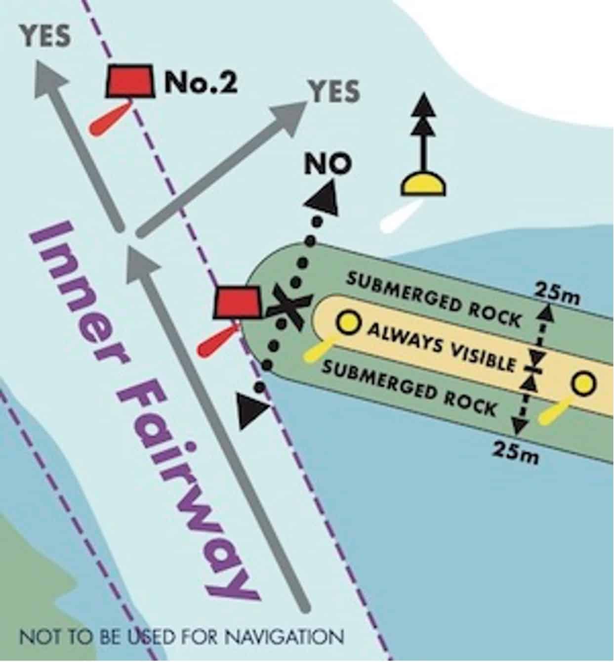
The western end, on the Inner Fairway extremity, is marked by a red channel mark Fl.R.2s and the eastern end by a green starboard channel mark Fl.Y.5s.

Do not cut inside between these channel marks and the ends of the breakwater. There is limited clearance

Diagram 1 below: A transverse cross-section of Cowes Breakwater showing extent of submerged toes
Diagram 2 below: The western end of Cowes Breakwater and suggested safe routes

A large wind shadow may exist on the lee side of the breakwater, particularly in light winds and localised tidal eddies.

If travelling east-west along the northern side of the breakwater, you may not be visible to craft northbound in the Inner Fairway. Avoid entering the Inner Fairway close to the western end of the breakwater so as to allow a full appraisal of the situation.

Avoid passing through the area south of the breakwater due to the presence of moorings and the limited depth of water unless proceeding to a mooring in the immediate vicinity.

The Cowes Breakwater is private property. Landing is strictly prohibited and an offence under the Cowes General Directions

See Cowes Local Notices To Mariners for more information

UKHO charts

The United Kingdom Hydrographic Office (UKHO) is an organisation within the UK government responsible for providing navigational and other hydrographic information for national, civil and defence requirements.

Cowes Harbour Commission (CHC) uses UKHO charts in the promulgation of navigation safety information, including the Cowes Local Notices To Mariners.

UKHO charts referred to by CHC on this website and in Cowes Local Notices To Mariners include:

  • 2038 – South Coast, Southampton Water and Approaches
  • 2793 – Cowes Harbour and River Medina
  • SC2793 – Cowes Harbour and River Medina

Visit the UKHO website for information on UKHO products and servicesAdmiralty digital charts, and Admiralty paper charts.

© Crown Copyright and/or database rights. Reproduced by permission of the Controller of Her Majesty’s Stationery Office and the UK Hydrographic Office (www.ukho.gov.uk).

Navigation within Cowes Harbour

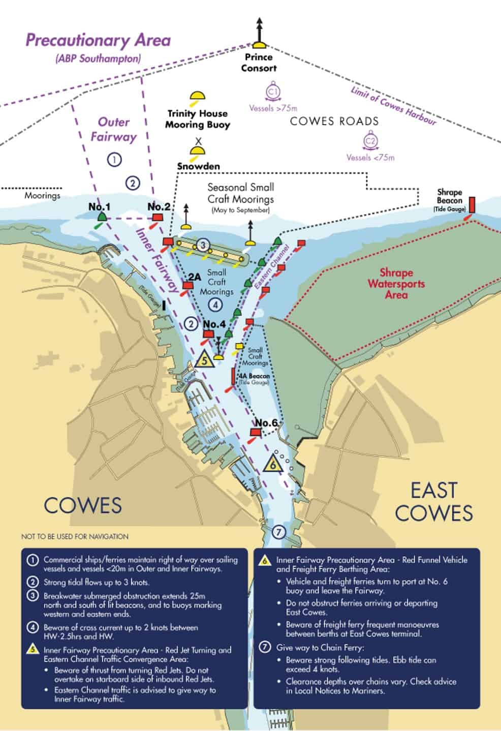
Good seamanship calls for the fairways (which extend from the northernmost harbour limit near Prince Consort Buoy south to the Folly Inn and beyond) to be navigated with caution and due regard to other vessels.

In particular, all vessels are required to keep to the starboard side of the Outer and Inner Fairways when practicable. However, large commercial vessels can often only navigate in the centre of the fairways and smaller vessels must not impede their passage.

The Cowes Outer Fairway extends 500m north of Nos. 1 and 2 buoys. All vessels must comply with Rule 9 of the Collision Regulations: Navigation in Narrow Channels. Vessels should enter and leave the Inner Harbour between the green No. 1 and red No. 2 fairway buoys.

Vessels entering the Inner Fairway from the Eastern Channel or marinas, should do so with caution and give way to any vessel already within the Inner Fairway. Before starting any manoeuvre to turn across the vessel traffic or enter any marina always give close attention to all other vessels in the vicinity, especially those astern.

A sailing vessel fitted with an auxiliary engine must proceed with the engine running and ready for immediate use in the Inner Harbour.

Certain activities are not permitted within the main harbour fairways: towing of persons; kite surfing; wind surfing; paddle boarding, and swimming as per General Direction 4.4.

Eastern Channel

The Eastern Channel connects the eastern approaches to Cowes with the Inner Fairway, enabling small craft up to 20m in length to avoid the main harbour entrance when arriving or departing Cowes from/to the north and east.

Vessels in the Eastern Channel must adhere to the harbour speed limit of 6 knots through the water and no wash.

Small vessels may use the Eastern Channel provided there is sufficient water in relation to their draught. The current tide height can be found here or on the four tide boards located around the harbour, including on the Shrape Beacon (east of the entrance to the Eastern Channel) and on the 4A Beacon at the Inner Fairway junction.

The Eastern Channel is, at its narrowest, 35m wide and the dredged depth is 2.25 metres below chart datum. Harbour users are advised that shallow water lays either side of the channel until passing north of the Cowes Breakwater. Keep to the buoyed channel and do not to enter the ‘small craft mooring’ areas either side; these are prohibited areas.

Vessels joining or leaving the Eastern Channel should give way to all vessels navigating in the Inner Fairway

A west-southwesterly current of up to 2 knots during spring tides may be experienced between HW-2.5hrs and HW, west of the Shrape Breakwater. A northwesterly current of up to 1.5 knots during spring tides may be experienced from HW+3hrs to HW+5hrs, west of the Shrape Breakwater. Exercise caution to ensure the tide to not alter your course into that of other vessels using the Eastern Channel or vessels navigating in the Inner Fairway.

Inner Fairway Precautionary Areas

There are two Precautionary Areas in the Inner Fairway at Cowes Harbour.

Eastern Channel Traffic Convergence & Red Jet Turning Area
Upon arrival in Cowes, the Red Jet High Speed passenger ferry executes a 180º turn prior to berthing alongside Jubilee Pontoon at Town Quay in Cowes. Significant wash is generated at the stern of the Red Jet during this manoeuvre.

Red Funnel Vehicle & Freight Ferry Berthing Area
The Red Funnel freight ferry manoeuvers between the linkspan at East Cowes Red Funnel Terminal berth and the lay-by berth to allow safe access and egress for the Red Funnel vehicle ferry.

Harbour users should navigate with particular caution in and around these two Precautionary Areas and vessels must not impede the safe passage of the ferries

It is strongly recommended that all vessels maintain a listening watch on VHF Channel 69 in the vicinity of the Inner Fairway Precautionary Areas.

Speed Limit and Wash

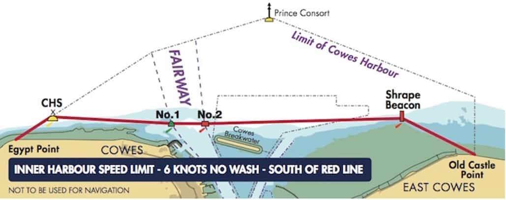
The speed limit in the Inner Harbour at Cowes is 6 knots through the water. All craft must comply with the Cowes Harbour speed limit and wash regulations

The Inner Harbour 6 knot speed limit applies in the Cowes Harbour jurisdiction and within 100m of the Mean High Water Mark west and east of the harbour entrance as far as Egypt Point and Old Castle Point

Navigate with care and caution and keep a good lookout for other vessels and swimmers in the water off the beach at Prince’s Green in Cowes.

Do not create wash in the Inner Harbour and within 100m of the shore from Egypt Point to Old Castle Point.

Inner Harbour speed limit – 6 knots no wash – south of red line

Harbour users are reminded to proceed at a safe speed at all times. Do not produce wake or wash that could cause a nuisance to other harbour/river users. The harbour is used by a wide variety of vessels some of which have a low freeboard and could easily be swamped.

The marinas and pontoons lining the fairway accommodate a range of vessels that are susceptible to damage from excessive wash and wake. Remember to look behind you and check your wash.

Users are reminded of General Directions 3.2 and 3.3, which are the regulations for speed limit and wash in Cowes Harbour. A vessel found to be in breach of a General Direction, or which causes damage or injury may find themselves in court and on summary conviction, could be fined up to £2,500.

Radio Communications

The Cowes Harbour Master maintains a listening watch on VHF Channel 69 from 0800 – 1800, extending to 0800 – 1900 during British Summer Time (BST). Hours may be extended at weekends in the summer. Call sign ‘HM1’. Safety information and berthing advice is available on request.

When navigating in and around Cowes Harbour, all vessels are strongly recommended to maintain a listening watch on VHF Channel 69. This is mandatory for vessels over 20m

All vessels of 20m LOA and above must give notice of their intentions on VHF Channel 69 to ‘All ships in Cowes Harbour’  as well as giving adequate notice to the Cowes Floating Bridge of your intention to pass if applicable as follows:

Inbound
• Prior to entering the Outer Harbour
• 250m north of Cowes Chain Ferry (at Shepards  Marina)
• Folly Inn (vessels bound for Newport)

Outbound
• Folly Inn
• Kingston Wharf
• 250m south of Cowes Chain Ferry (at Cowes Harbour Services Fuel Berth)

The call shall give the following information:
• Vessel’s name
• Vessel’s position
• Intention

Cowes Floating Bridge has right of way over all river traffic, however, any vessel requiring an unimpeded passage is required to establish early contact minimum 5 minutes (call sign ‘Cowes Chain Ferry’) and agree on VHF Channel 69 which side the floating bridge will hold for your passage. Between midnight and 0500 when out of service a minimum of 10 minutes notice shall be given to enable them to start their engines and clear the fairway.