3.78 m VHF: Channel 69 Report an Incident

News - 26/11/15

Cowes Breakwater Project November 2015 report

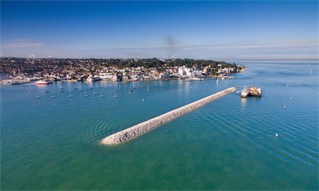
As reported in our newsletter last month, contractors Boskalis Westminster have finished the rock armouring of the new Cowes Breakwater. The removal of surplus gravel material to the north of the breakwater has been delayed due to the requirement for contractors to obtain a new MMO (Marine Management Organisation) consent for its removal and disposal. The process of obtaining the MMO consent is likely to take around eight weeks, during which time the breakwater Exclusion Zone continues to remain in force.

Harbour tidal modelling work
The new harbour tidal model, commissioned by CHC from consultant hydrodynamic engineers ABPmer, will now be utilised for a wide range of model runs to optimise the next phases of planned harbour infrastructure, the Shrape breakwater extension and dredging of the new Eastern Channel.

Sedimentation and bathymetric surveys
Initial sedimentation surveys (bed material grab sampling, water sampling, and turbidity monitoring) have now been carried out to provide further data to assist an improved understanding of the Cowes Harbour baseline sedimentation budget.

Following analysis of the materials, the results will then be used in the sedimentation model for Cowes Harbour, at present under construction by ABPmer. The information will also facilitate the development of an independent, conceptual understanding of the Medina Estuary’s evolution and hydrodynamics. The data will provide new baseline information for the interim and long-term sedimentation and bathymetric monitoring, and assist with the development of the proposed new sustainable dredging management plan for Cowes Harbour and the Medina Estuary.

Multi-beam harbour survey
Meanwhile, Shoreline Surveys has been appointed to carry out a full multi-beam survey of the whole harbour area that will include all marinas and third-party owned areas where permission has been granted. CHC would like to thank stakeholders for their assistance and cooperation during the survey, which is due to be carried out this week.

This new multi-beam survey will provide a greater degree of accuracy for assessing rates of sedimentation and erosion between surveys, and will be used as the new post-breakwater construction baseline bathymetric survey for the whole Medina Estuary.

Photo: Aerial view of the new Cowes Breakwater, October 2015. Credit Boskalis Westminster.